Home › Campaign routes › Second fall 1767
The second fall of Ayutthaya, 1767: the camps, the breach and what was destroyed
Two Burmese armies sent by King Hsinbyushin met at Ayutthaya early in 1766, ringed the city with camps and stayed through the floods. On the night of 7 April 1767 the wall at Hua Ro collapsed, undermined by fire in tunnels beneath it, and the city was sacked and burned. This page maps the Burmese camps and the breach, lists the palaces and temples that were destroyed and what can still be seen, and suggests places to visit and eat near each spot.
- Burmese camp (numbers match the list below)
- Area shown in the close-up map below
- Other places on our map
1. Pak Nam Prasop camp, 2. Pho Sam Ton camp, 15. Si Kuk camp lie outside this map, about 8.3 km, 6.2 km, 12.1 km from the Ancient Royal Palace
What happened, in order
- January 1766
Ne Myo Thihapate wins at Pak Nam Prasop and the two Burmese armies reach the outskirts of the city.
- September 1766
The Burmese stay through the floods. Maha Nawrahta moves to the Phu Khao Thong area and Ne Myo Thihapate to Pho Sam Ton.
- 3–4 January 1767
Phraya Tak breaks out through the encirclement to the east. On the night of the 4th a fire destroys some 10,000 houses in the city.
- March 1767
The Chinese camp at Khlong Suan Phlu, the Portuguese village and the stronghold at Wat Chaiwatthanaram fall. The Portuguese churches are burned on 23 March.
- Late March 1767
Ne Myo Thihapate builds three stockades on the Hua Ro side, bridges the river and digs five tunnels under the foot of the wall.
- 7 April 1767
About 3 pm the Burmese fire the tunnels; at dusk the wall subsides; about 8 pm the order is given to attack on every side, and by midnight they are inside.
- Late April 1767
Most of the Burmese army leaves with its captives and plunder, leaving Suki's force at the Pho Sam Ton camp.
- November 1767
King Taksin returns by river and retakes the Pho Sam Ton camp.
Where the Burmese camped
A Burmese commander who took part counted 27 siege camps; the Thai chronicles name 18. These are the ones that can be placed on a map: the main camps in the north, the close-in camps at Hua Ro, and the camps on the west and south.
Ne Myo Thihapate's main camp at Pak Nam Prasop (Wat Pa Fai)
Ne Myo Thihapate's first main camp, early 1766
Today: Wat Pa Fai is an abandoned temple on private land, with a pavilion sheltering Buddha images and fragments of Early Ayutthaya sandstone Buddhas; ask the owners before visiting. Only a short ditch remains of the mouth of the Pho Sam Ton channel near the bridge.
Show on the mapGoogle Maps ↗Details, sights and food nearby →
The Pho Sam Ton camp
The main northern camp, where captives were held after the fall
Today: The camp area was dug up for bricks around the 1950s and is now a large pond with brick fragments in the soil and a shrine to King Taksin.
Show on the mapGoogle Maps ↗Details, sights and food nearby →
Burmese camps on the Phaniat plain
The Phaniat plain, where the Burmese burned the kraal pavilion and camped
Today: The elephant kraal seen today was restored in the Rattanakosin period and can be visited from the Phu Khao Thong–Phaniat road.
Show on the mapGoogle Maps ↗Details, sights and food nearby →
Burmese camp at Wat Chedi Daeng
A gun camp bombarding the city from the north
Today: An active temple where locals come to have their vehicles blessed. There is no red chedi despite the name, but a red bell tower stands by the canal and a Late Ayutthaya redented chedi rises behind the sermon hall.
Show on the mapGoogle Maps ↗Details, sights and food nearby →
Burmese camp at Wat Sam Wihan
A gun camp facing the Maha Chai Fortress line
Today: An active temple with a boat-shaped vihara holding a large reclining Buddha, a big bell-shaped chedi visible across town, and an ordination hall with its full set of boundary stones.
Show on the mapGoogle Maps ↗Details, sights and food nearby →
Burmese camp at Wat Monthop
A gun camp on Ko Loi, opposite Hua Ro
Today: A temple on a small island created by later canal digging, with an ordination hall, a vihara and a bell tower, a short walk from Hua Ro market and the long-tail boat landing.
Show on the mapGoogle Maps ↗Details, sights and food nearby →
Burmese camp at Wat Krajom
A gun camp on the east bank of the Front City Canal
Today: Nothing of the temple or the camp is visible above ground; houses now cover the site. The map point marks the former temple.
Show on the mapGoogle Maps ↗Details, sights and food nearby →
Burmese stockade at Wat Mae Nang Plum (Khok Phama)
The stockade at the head of the bridge used to reach the tunnels
Today: Two earthen mounds survive on the south side of the road, known locally as Khok Phama (the Burmese mounds); Chinese residents later used them as a burial ground. The temple is still active.
Show on the mapGoogle Maps ↗Details, sights and food nearby →
Burmese siege works at Hua Ro (bridge and tunnels)
The siege works with the tunnels: where the wall came down
Today: The Hua Ro market area, with a memorial wall on U-Thong Road.
Show on the mapGoogle Maps ↗Details, sights and food nearby →
Burmese camp at Wat Na Phra Men
The camp facing the palace across the city canal
Today: An Ayutthaya-period ordination hall that escaped the fire, with a large crowned Buddha image. The temple is active and open to visitors.
Show on the mapGoogle Maps ↗Details, sights and food nearby →
Burmese camp at Wat Phu Khao Thong
Maha Nawrahta's camp to the north-west
Today: The Golden Mount chedi still dominates the fields, close to the King Naresuan the Great monument on Thung Phu Khao Thong.
Show on the mapGoogle Maps ↗Details, sights and food nearby →
Burmese camp at Wat Tha Ka Rong
Maha Nawrahta's vanguard, about 500 metres from the wall
Today: An active riverside temple with a weekend floating market.
Show on the mapGoogle Maps ↗Details, sights and food nearby →
Burmese camps at Ban Pom, Thung Prachet
A gun camp on the west bank
Today: The Prachet fields are still open land, with the prang of Wat Kasattrathirat on the river and Wat Worachet in the middle of the fields. No trace of the camps remains.
Show on the mapGoogle Maps ↗Details, sights and food nearby →
Burmese camp at Ko Kaeo
The camp on the south-east
Today: Wat Ko Kaeo is an active temple with a Late Ayutthaya-style ordination hall facing the Pa Sak River and a shrine to King Taksin.
Show on the mapGoogle Maps ↗Details, sights and food nearby →
The Si Kuk camp
Maha Nawrahta's base to the west
Today: Wat Si Kuk has the ruin of a redented chedi and a shrine to Maha Nawrahta. A 1966 survey by N. Na Paknam described a brick wall the Burmese built across the neck of the bend, enclosing several dozen rai.
Where they broke in
After the first fall Ayutthaya had walls along the water on every side, so for the first year the Burmese could not storm it. They starved the city, picked off its outposts one by one and pushed their stockades up to the walls. Early in 1767 the outer strongholds fell in turn: the Chinese camp at Khlong Suan Phlu, the Portuguese village and Wat Chaiwatthanaram.
The point chosen was Hua Ro, the north-east corner, at the weir that crossed the old Lopburi River. Ne Myo Thihapate built three stockades, bridged the river from the Wat Mae Nang Pluem bank and dug five tunnels under the foot of the wall beside Maha Chai Fortress. A last Siamese sortie against the camps cost about 800 men.
On the afternoon of Tuesday 7 April 1767 the Burmese packed the tunnels with fuel and fired the foundations. At dusk the wall subsided. About 8 pm the signal gun was fired and Burmese troops went in through the gap and over ladders on every side at once.
- Burmese camp; numbers match the list of camps above
- Line of the bridge from the stockade at Wat Mae Nang Pluem to the siege works under the wall
- Where the wall came down on the night of 7 April 1767 (today's Hua Ro market)
Burmese siege works at Hua Ro (bridge and tunnels)
Where: North-eastern corner of the city island at Hua Ro market, on U-Thong Road near Chan Kasem Palace approximate
In late March 1767 Ne Myo Thihapate built three stockades on the Hua Ro side, bridged the river opposite the Hua Ro weir and dug five tunnels under the foundations of the wall. A Siamese sortie against the camps cost about 800 men. A Burmese commander's account says dry grass and branches were packed into the tunnels, soaked with oil and fired until the wall collapsed; the Burmese stormed in and the city fell in April 1767.
Today: The Hua Ro market area, with a memorial wall on U-Thong Road.
Still debated: Sources differ by a few days on when the tunnels were fired; Thai sources date the fall to 7 April 1767.
Show on the mapGoogle Maps ↗Sights and food near this spot →
What was destroyed
This time the city was sacked and burned, people and treasure were carried off to Burma, and Ayutthaya never became the capital again. Scholars point out, though, that not all the damage seen today was done on the night of the fall: part of it came from treasure hunting and brick removal over the following decades.
- BurnedThe Grand Palace
Burned on the night of the fall; only the foundations of its throne halls remain.
- BurnedWat Phra Si Sanphet and its great Buddha
The vihara was burned and the gold-covered standing Buddha, Phra Si Sanphet, was damaged beyond repair. Tradition says the Burmese lit fires to melt off its gold; this is disputed.
- DamagedWihan Phra Mongkhon Bophit
The burning roof fell on the image, breaking its head and right arm.
- BurnedWat Mahathat, Wat Ratchaburana, Wat Thammikarat
The royal temples in the centre were burned and many Buddha images were smashed or beheaded.
- BurnedChan Kasem Palace (the Front Palace)
Next to the breach; burned to ruins and abandoned.
- BurnedThe Portuguese village and the Chinese camp at Khlong Suan Phlu
The three Portuguese churches were burned on 23 March 1767, and the Chinese quarter at Khlong Suan Phlu was destroyed with the city.
- BurnedOrdinary houses
Burmese accounts say a fire on the night of 4 January 1767 destroyed some 10,000 houses inside the walls, three months before the fall.
- Taken awayPeople and the royal family
Perhaps 30,000 people were marched to Burma, among them the former King Uthumphon and many of the royal family. The captives were gathered at Martaban before going on to Ava.
- Taken awayCannon, royal barges and treasure
The Burmese chronicle says more than 500 cannon were rafted to Ava, with royal barges and valuables.
- PeopleKing Ekkathat
He died after the fall. Thai chronicles say he fled to Ban Chik near Wat Sangkhawat, went days without food and died at the Pho Sam Ton camp; the Burmese chronicle says he was shot at a city gate.
- SparedWat Na Phra Men
Not burned, by tradition because the Burmese camped there, so its Ayutthaya-period ordination hall survives intact.
- Later damageDamage after the war
A French missionary's letter of 1769 describes starving Thais, and especially Chinese, stripping the temples and breaking up Buddha images for metal. Under Rama I to Rama III bricks from the walls and palaces were taken to build Bangkok.
Evidence you can still see
The whole Ayutthaya Historical Park is evidence of this war. These are the places that tell the story of the fall most clearly; some are as far away as Bangkok and Myanmar.
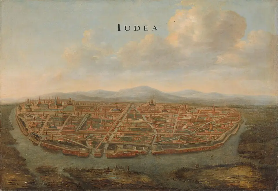
Ayutthaya before its destruction
This oil painting by the Dutchman Johannes Vingboons, made around 1662, shows the walled city with its grid of canals and its many prangs and chedis about a century before the fall. The original is in the Rijksmuseum, Amsterdam.
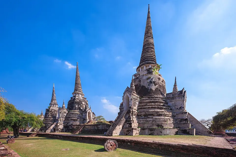
The three chedis of Wat Phra Si Sanphet
The three bell-shaped chedis survived the fire, but the royal vihara in front of them, which housed the Phra Si Sanphet image, is reduced to its base and column stumps.
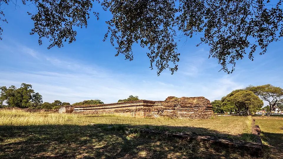
Throne-hall foundations in the Grand Palace
A palace used for more than three centuries is now only brick foundations, partly from the fire on the night of the fall and partly because its bricks were taken to build Bangkok under Rama I to Rama III.
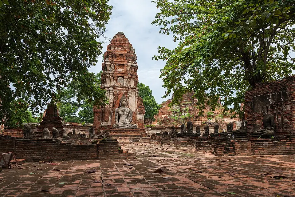
Wat Mahathat
Rows of headless Buddha images along the galleries, and the Buddha head held in tree roots, have become the lasting image of Ayutthaya after the fall. The main prang collapsed later, in the Bangkok period.
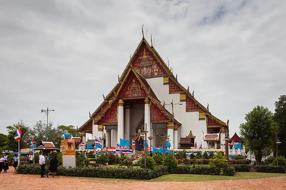
Phra Mongkhon Bophit
The burning roof fell and broke the image's head and right arm. Phraya Boran Ratchathanin repaired the image in 1920, and the vihara seen today was finished in 1957, helped by a donation from the Prime Minister of Burma, who visited Ayutthaya in 1956.
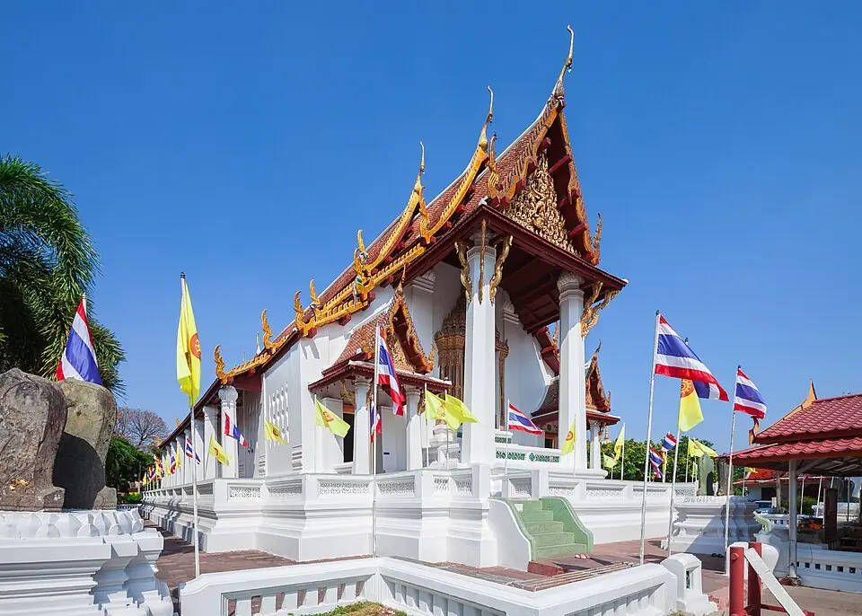
Wat Na Phra Men, the temple that survived
An Ayutthaya-period ordination hall that was not burned, showing what the royal temples of the city looked like before the fall.
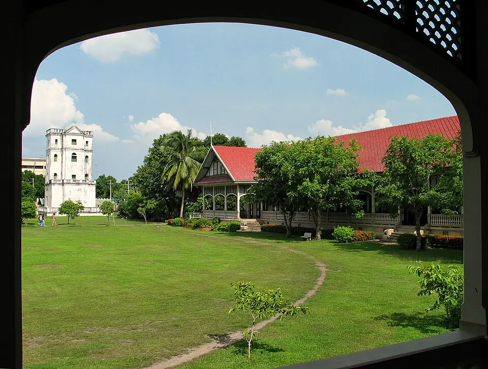
Chan Kasem Palace, beside the breach
The Front Palace stood next to Hua Ro. It was burned and left in ruins until King Mongkut restored it as a residence for his visits to the old capital; it is now the Chan Kasem National Museum. The breach itself was at today's Hua Ro market, where a memorial wall stands on U-Thong Road.
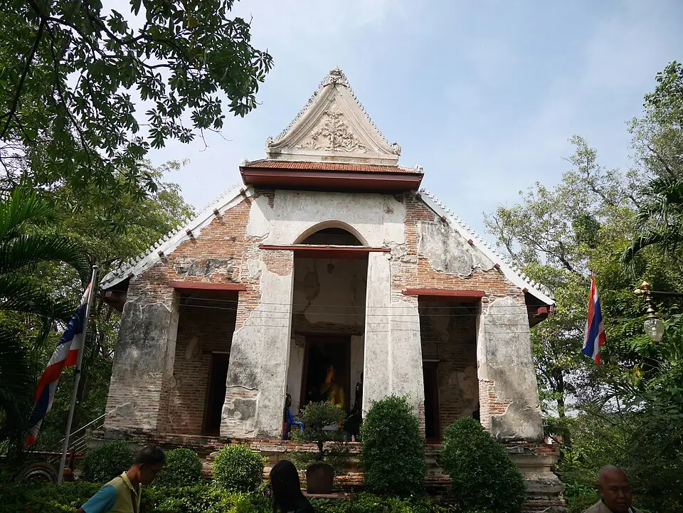
The 'Burmese mounds' at Wat Mae Nang Pluem
Two earthen mounds south of the road in front of the temple, known locally as Khok Phama, are believed to be the remains of the stockade at the head of the bridge the Burmese used to reach the tunnels under the Hua Ro wall. (The photo shows the temple.)
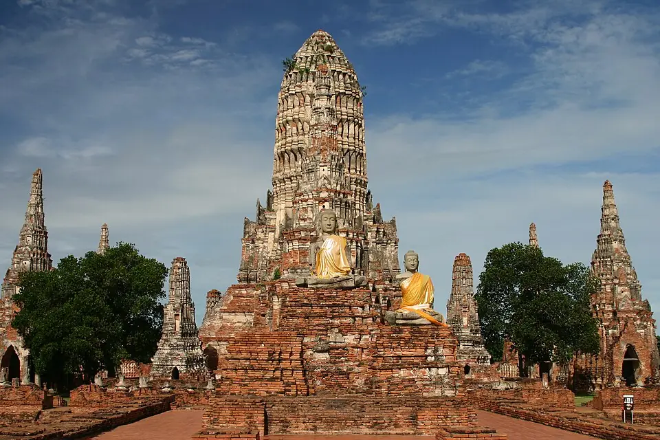
Wat Chaiwatthanaram, the last stronghold outside the walls
The Siamese held this temple as their south-western stronghold for nine days before it fell. Almost all the Buddha images in its surrounding towers have lost their heads.
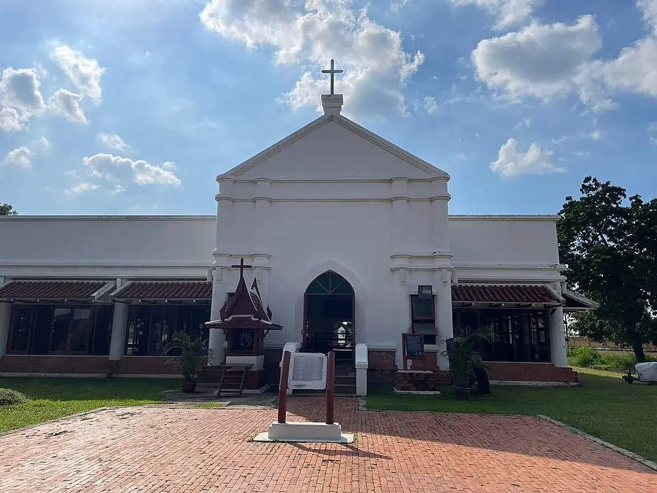
The Portuguese village
The excavated ruin of the Dominican church, with skeletons from its cemetery on display. The Portuguese camp fell on 21 March 1767 and the churches were burned two days later.
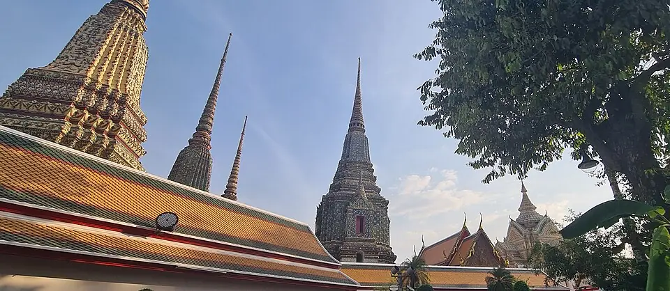
Phra Maha Chedi Si Sanphetdayan, Wat Pho, Bangkok
In 1790 King Rama I had the damaged Phra Si Sanphet image brought down to Bangkok and enshrined inside the first great chedi of Wat Pho, the one faced with green tiles. The most important Buddha image of the old capital lies within it.
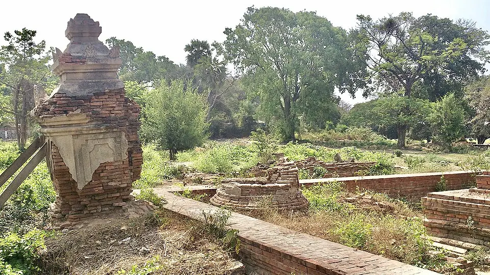
The stupa at Linzin-gon cemetery, Amarapura
A brick stupa in a cemetery near U Bein Bridge in Myanmar, thought by some to hold the ashes of King Uthumphon, who was taken away with the people of Ayutthaya and died there. The identification is not settled.
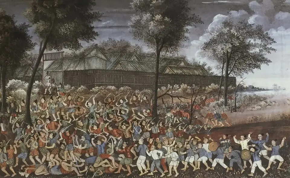
Chao Tak attacks the Pho Sam Ton camp (painted 1887)
From the series of chronicle paintings made under King Chulalongkorn, 120 years after the event: an illustration, not contemporary evidence. The real camp at Pho Sam Ton was dug up for its bricks and is now a pond.
Places to visit and eat nearby
We group the key places of this war into six areas. The first five lie around the city island, within reach of each other by bike or car; the last is out of town to the north and needs a drive.
Hua Ro: where the wall came down
Start at Hua Ro market and the memorial wall on U-Thong Road, walk to Chan Kasem Palace, then cross the city canal to Wat Mae Nang Pluem to see the Burmese mounds. Everything is within walking or cycling distance.
In this area:9Hua Ro siege works8Khok Phama mounds6Wat Monthop camp7Wat Krajom camp
Places to visit
- Maha Chai Fortress, Hua RoThe corner of the wall the Burmese undermined with tunnels and fire until it collapsed on the night the city fell, 7 April 1767
- Wat Mae Nang PluemThe bank opposite Maha Chai Fortress where the Burmese camped to attack the city; what remains is Khok Phama, the "Burmese Mound", near the temple
- Wat Monthop (Ko Loi) ↗Google Maps
Where to eat
- Hua Ro Market (ตลาดหัวรอ)near Maha Chai Fortress, Hua RoFresh produce, ready-made dishes and local sweets
- Je Ni's Rice Porridge (โจ๊กเจ๊นิ), Hua Ro Marketnear Maha Chai Fortress, Hua RoHot rice porridge (jok) for breakfast
- Buk's Red Pork Rice (บั๊กข้าวหมูแดง), Hua Ro Marketnear Maha Chai Fortress, Hua RoRed roast pork and crispy pork on rice
- Nai Liak Beef Noodles (ก๋วยเตี๋ยวเนื้อนายเลียก)near Maha Chai Fortress, Hua RoBeef noodles with stewed beef, offal and beef balls
- Restaurants in this area on Google Maps ↗
The Phaniat plain: the gun camps in the north
North across the bridge from Hua Ro is the Phaniat peninsula, with Wat Sam Wihan, Wat Chedi Daeng and the elephant kraal, where the Burmese set up camps to bombard the city.
In this area:3Phaniat camps4Wat Chedi Daeng camp5Wat Sam Wihan camp
Places to visit
- Wat Mae Nang PluemThe bank opposite Maha Chai Fortress where the Burmese camped to attack the city; what remains is Khok Phama, the "Burmese Mound", near the temple
- Maha Chai Fortress, Hua RoThe corner of the wall the Burmese undermined with tunnels and fire until it collapsed on the night the city fell, 7 April 1767
- Elephant Kraal (Phaniat) ↗Google Maps
- Wat Sam Wihan ↗Google Maps
- Wat Chedi Daeng ↗Google Maps
Where to eat
- Hua Ro Market (ตลาดหัวรอ)near Maha Chai Fortress, Hua RoFresh produce, ready-made dishes and local sweets
- Je Ni's Rice Porridge (โจ๊กเจ๊นิ), Hua Ro Marketnear Maha Chai Fortress, Hua RoHot rice porridge (jok) for breakfast
- Buk's Red Pork Rice (บั๊กข้าวหมูแดง), Hua Ro Marketnear Maha Chai Fortress, Hua RoRed roast pork and crispy pork on rice
- Nai Liak Beef Noodles (ก๋วยเตี๋ยวเนื้อนายเลียก)near Maha Chai Fortress, Hua RoBeef noodles with stewed beef, offal and beef balls
- Restaurants in this area on Google Maps ↗
The centre of the island: the burned palace and temples
The historical park is the area that suffered most. Walk from the Grand Palace, Wat Phra Si Sanphet and Wihan Phra Mongkhon Bophit to Wat Mahathat in half a day, then cross the city canal to Wat Na Phra Men, the temple that was not burned.
In this area:10Na Phra Men camp
Places to visit
- Wat Phra Si SanphetThe palace temple whose gold-covered Phra Si Sanphet image was burned and stripped of its gold on the night the city fell
- Ancient Royal PalaceWhere the young Sin was presented as a royal page, and where some chronicles say King Taksin spent the night after recovering the capital
- Wat Na Phra MenThe temple the Burmese used as a position for firing on the palace, which is why it escaped the fire on the night the city fell
- Wat MahathatThe great temple at the centre of the city island that was burned, its Buddha images beheaded, when the city fell
- Wat Choeng ThaThe temple where the boy Sin is said to have studied under Phra Achan Thongdi, before he grew up to be Phraya Tak
Where to eat
- Pranom Shredded Chicken Noodles, Tha Wasukri Branch (ก๋วยเตี๋ยวไก่ฉีก คุณประนอม สาขาท่าวาสุกรี)near Wat Na Phra MenShredded-chicken noodles in tom yum broth, braised chicken feet
- Pa Lek Boat Noodles (ก๋วยเตี๋ยวเรือป้าเล็ก)near Wat MahathatPork and beef boat noodles in small bowls
- Ayutthaya Night Market (อยุธยาไนท์มาร์เก็ต)near Wat MahathatLocal food and sweets in a retro atmosphere
- Restaurants in this area on Google Maps ↗
The south: Pom Phet, Wat Phanan Choeng and the Portuguese village
The Siamese strongholds in the south fell less than a month before the city. Pom Phet, Wat Phanan Choeng, Baan Hollanda, the Japanese village and the Portuguese village line the river here.
In this area:14Ko Kaeo camp
Places to visit
- Wat Phanan ChoengThe temple of the riverside Chinese community, near the camp of the Chinese volunteers at Khlong Suan Phlu in the war of the fall
- Phet FortressThe river-mouth fort at the south-east corner, on the side where the Chinese volunteers' junks were trapped by a Burmese iron chain
- Portuguese SettlementThe Portuguese community whose camp fell in March 1767; some of its soldiers went on to serve in King Taksin's army
Where to eat
- Phae Krung Kao (แพกรุงเก่า)near Wat Phanan ChoengCharcoal-grilled river prawns, green curry with clown knifefish balls
- Roti Sai Mai Abeedeen-Pranom Sangaroon (โรตีสายไหม อาบีดีน-ประนอม แสงอรุณ)near Phet FortressRoti sai mai (Thai cotton-candy roti), with a choice of 2 flavours of wrap
- Baan Pomphet (บ้านป้อมเพชร)near Phet FortressGrilled river prawns and freshwater shellfish dishes
- Restaurants in this area on Google Maps ↗
The west: Wat Chaiwatthanaram, Phu Khao Thong and Tha Ka Rong
Maha Nawrahta's army lay on this side. Wat Chaiwatthanaram was the last Siamese stronghold outside the walls, while Wat Tha Ka Rong and Ban Pom were Burmese gun camps. A road along the Chao Phraya links them by car or bike.
In this area:11Phu Khao Thong camp12Tha Ka Rong camp13Ban Pom camps
Places to visit
- Wat ChaiwatthanaramThe riverside temple on the west bank that served as a stronghold on the southern side, holding out against the Burmese for nine days before it fell
- Wat Phu Khao ThongThe plain where Phraya Tak went out to fight the Burmese early in the war, and where the Burmese commander later set up his camp
- Wat Tha Ka Rong ↗Google MapsRead about it on naresuan.com →
- Wat Kasattrathirat ↗Google MapsRead about it on naresuan.com →
Where to eat
- Rimsuan Restaurant (ร้านริมสวน)near Wat ChaiwatthanaramSouthern Thai food, yellow curry with river fish
- Ayutthayaromnear Wat ChaiwatthanaramTom som (sour soup) with squid and fresh chillies, fried river fish in chu chee curry, Thai desserts with fresh coconut milk
- Kaow Laor (ขาวละออ)near Wat ChaiwatthanaramRiver prawns, river fish, clown knifefish cakes
- Wat Tha Ka Rong Floating Market (ตลาดน้ำวัดท่าการ้อง)near Wat ChaiwatthanaramAyutthaya boat noodles and riverside snacks
- Restaurants in this area on Google Maps ↗
Out of town to the north: Pho Sam Ton
Ne Myo Thihapate's main camps lay 6 to 8 kilometres north of the island, in Bang Pahan district, and need a drive. A pond, brick fragments and a shrine to King Taksin are what remain.
In this area:2Pho Sam Ton camp1Pak Nam Prasop camp
Places to visit
- Pho Sam Ton campThe main Burmese camp north of the city, which King Taksin retook at the end of October 1767
- Wat Woranayok Rangsan (Wat Khao Din) ↗Google Maps
Where to eat
After the fall
Most of the Burmese army left within weeks, needed against a Chinese invasion in the north, leaving Suki's force to guard captives at the Pho Sam Ton camp. Seven months later King Taksin came back by river and took it, but Ayutthaya was too badly damaged to be a capital again and he set up his court at Thonburi.
The ruined city was abandoned, dug over for treasure and quarried for bricks to build Bangkok. Survey and conservation began under King Chulalongkorn, and the site was inscribed on the World Heritage List in 1991.
Where historians still disagree
- Who destroyed Ayutthaya: B. J. Terwiel points out, from French missionary letters, that most of the Burmese army left on 25 April 1767, only 18 days after the fall, so much of the damage probably came later, from treasure hunting, the breaking up of Buddha images for metal, and the removal of bricks to build Bangkok.
- Was Phra Si Sanphet burned for its gold: the tradition that the Burmese melted the gold off with fire is challenged by Rungroj Piromanukul in a book whose title says the image was not burned for its gold when the city fell. What is certain is that it was too damaged to restore, and Rama I enshrined it in a great chedi at Wat Pho.
- How King Ekkathat died: of starvation after fleeing to Ban Chik, in the Thai chronicles; shot at a city gate, in the Burmese chronicle.
- The number of camps: 27 in a Burmese commander's account and 18 in the Thai chronicles, because sub-camps and camps that moved are counted differently.
- Date and time: Thai sources date the fall to Tuesday 7 April 1767; accounts differ by a few days on when the tunnels were fired.
- Why Wat Na Phra Men survived: that the Burmese spared it because they camped there is tradition; no Burmese source confirms it directly.
Frequently asked questions
What was the date of the second fall of Ayutthaya?
The night of Tuesday 7 April 1767, the 9th waxing day of the 5th lunar month, in the reign of King Ekkathat, after a siege of about 14 months.
Where did the Burmese break in the second time?
Through the wall beside Maha Chai Fortress at Hua Ro, the north-east corner of the island. The Burmese bridged the river from the Wat Mae Nang Pluem bank, dug five tunnels under the wall and set fires in them until it collapsed. The spot is today's Hua Ro market.
What did the Burmese burn in 1767?
The Grand Palace, Wat Phra Si Sanphet, Wat Mahathat, Wat Ratchaburana, Chan Kasem Palace, the Portuguese village and a great many houses. The roof of Wihan Phra Mongkhon Bophit fell on its image. Wat Na Phra Men was not burned.
Where were the Burmese camps in 1767?
The main camps were at Pak Nam Prasop and Pho Sam Ton in the north. The close-in camps stood at Hua Ro and on the Phaniat plain, at Wat Sam Wihan, Wat Chedi Daeng, Wat Monthop and Wat Mae Nang Pluem, and on the west there were camps at Wat Phu Khao Thong, Wat Tha Ka Rong and Ban Pom.
Did the Burmese cause all the ruin seen today?
Not all of it. The fire on the night of the fall destroyed timber buildings and roofs, but contemporary evidence shows that after the war people stripped the ruins for valuables and melted down Buddha images, and in the early Bangkok period bricks from the walls and palaces were taken to build the new capital.
How is the second fall linked to King Taksin?
Phraya Tak fought in the defence of the city from the start. Early in January 1767 he broke out to the east from his camp at Wat Phichai, gathered forces at Rayong and Chanthaburi, and came back by river to retake the Pho Sam Ton camp in November of the same year.
How did the first fall differ from the second?
In 1569 the enemy came in at the south-east corner over causeways built across the moat, helped by a spy inside; there is no record of the city being burned, and it remained a capital, as a vassal of Pegu. In 1767 the enemy tunnelled under the wall at Hua Ro, the north-east corner, and fired its foundations; the city was sacked and burned and never became the capital again.
- Tunnels and fire under the wall: the end of Ayutthaya – Silpa Wattanatham (in Thai)
- 27 Burmese camps around Ayutthaya, from a Burmese commander's account – Silpa Wattanatham (in Thai)
- The Burmese 'pincer' strategy before the second fall – Silpa Wattanatham (in Thai)
- B. J. Terwiel: Ayutthaya was not burned down by the Burmese alone – Silpa Wattanatham (in Thai)
- How the Burmese took the Ayutthaya captives to Ava after the second fall – Silpa Wattanatham (in Thai)
- Phra Si Sanphet, the great Buddha image whose appearance remains a mystery – Silpa Wattanatham (in Thai)
- The stupa of King Uthumphon and the Yodaya descendants in Burma – Silpa Wattanatham (in Thai)
- Siege of Ayutthaya (1766–1767) – Wikipedia
- Maha Chai Fortress – Ayutthaya Historical Research
- The Burmese Mounds (โคกพม่า) – Ayutthaya Historical Research
- Wihan Phra Mongkhon Bophit – Ayutthaya Historical Research
Last updated 13 November 2026