Home › Places › Wat Mae Nang Pluem
Wat Mae Nang Pluem and Khok Phama: the bank where the Burmese camped to attack Ayutthaya
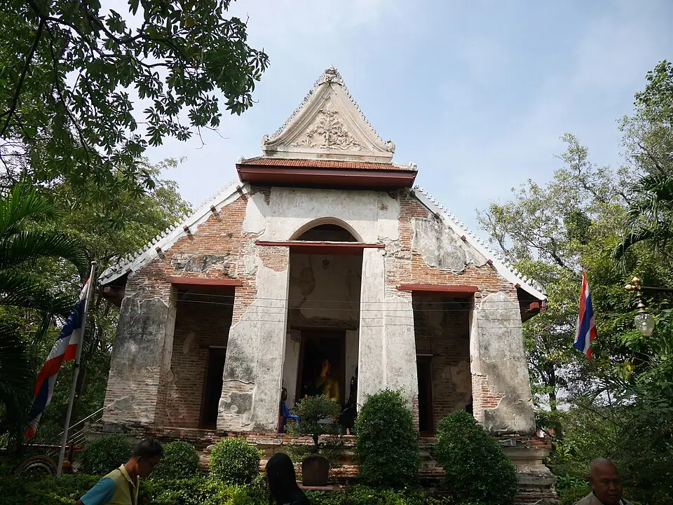
Wat Mae Nang Pluem stands on the north bank of Khlong Mueang, looking across the water to Hua Ro and Chandra Kasem Palace. In the war of the second fall, the riverbank in front of this temple was the site of the Burmese camp used to attack the corner of the city at Maha Chai Fortress, until the wall came down on the night of 7 April 1767. The remains of the camp were left as earth mounds that villagers call Khok Phama, and the temple itself still has monks, and people still come to pay respect to Luang Pho Khao.
This place through the periods
An old temple on the old Lopburi River, opposite the Hua Ro corner of the city. Legend ties the temple's name to a woman called Mae Nang Pluem. In peacetime it was the temple of the riverside community on the north bank.
Towards the end of the war the Burmese built a camp of earth ramparts and timber posts on the riverbank in front of Wat Mae Nang Pluem, on both sides of the point where they would build the bridge across to Maha Chai Fortress, and used this camp to bombard the city.
From the camps here the Burmese crossed the bridge and dug tunnels under the wall at Hua Ro, until the city fell on the night of 7 April 1767. The temple was not as badly damaged as the temples on the city island.
After the Burmese withdrew, the remains of the camp were left as earth mounds that villagers call Khok Phama. Later the Chinese used part of the mounds as a burial ground. The wihan was restored in the early Rattanakosin period.
A working temple with resident monks. Luang Pho Khao is a Buddha image people like to come and pray to. Two earth mounds can still be seen south of the road near the temple.
The Burmese camp in front of the temple
When Ne Myo Thihapate chose the Hua Ro corner as his main point of attack, because the channel was at its narrowest, the Burmese built a camp on the riverbank in front of Wat Mae Nang Pluem, on both sides of the point where they would bridge the river. The camp was made of earth ramparts and timber posts, to stop shot from the city wall, and they built forts on the ground in front of the wall as a further line.
The Siamese holding the opposite bank, around Wat Kudi Daeng, Wat Sam Wihan and Wat Mondop, were beaten by the Burmese one position after another. Once the Burmese had a bamboo bridge across the river, they went on to dig tunnels under the wall at Maha Chai Fortress, until the wall came down on the evening of 7 April 1767.
Khok Phama
After the Burmese withdrew, the remains of the camp were left as high earth mounds that villagers call Khok Phama, the "Burmese Mound". Later the Chinese of the area used part of the mounds as a burial ground. Today two earth mounds can still be seen south of the road near the temple. They are among the few traces that show the position of a Burmese camp of the war of the fall to the naked eye.
The chronicles name several Burmese camps set up at temples around the city. Researchers have not yet been able to match some of the names with present-day temples, so the position of each camp should be read with care.
A temple that survived the fires of war
Although it stood in the middle of the battlefield, Wat Mae Nang Pluem was not as badly damaged as the temples on the city island, so its main monuments can still be seen. The wihan was restored in the early Rattanakosin period, and the Fine Arts Department restored the chedi, the wihan and the Buddha images in 2000. Luang Pho Khao is a Buddha image people like to come and pray to. See this temple together with the Hua Ro area opposite and you get the full picture of the attack on the north-east of the city, from both banks.
The Hua Ro area after the war
When King Taksin came back to recover the capital late in 1767, the area around Maha Chai Fortress and Wat Mae Nang Pluem was nothing but the remains of camps and broken wall. King Taksin did not set up his capital at Ayutthaya, so people gradually came back of their own accord to build homes along the river, and Hua Ro became a trading community again in the Rattanakosin period.
On this site's one-day trip, Wat Mae Nang Pluem follows Hua Ro, a few minutes away across the bridge. Standing on the temple side and looking back at the line of the wall on the island side shows how close the Burmese camp was to the city, with only the river between them, which is why the siege pressed so hard on the city in its last phase.
If you come in the morning, start at Hua Ro Market and then cross over: you get breakfast and a view of both banks of the river in one morning.
Where historians still disagree
- Is Khok Phama really a Burmese camp? It is a local belief that fits the chronicles, but no excavation has yet confirmed it.
Visiting information
- Dress modestly, as this is a working temple with resident monks and people come here to worship.
- Do not climb the chedi or sit on the stucco lions.
- Walk across to the Hua Ro side to see the point where the wall came down, on the same route.
Frequently asked questions
Where is Khok Phama?
Near Wat Mae Nang Pluem, on the north bank of Khlong Mueang, south of the road: two earth mounds believed to be the remains of a Burmese camp.
What does Wat Mae Nang Pluem have to do with the fall of Ayutthaya?
The Burmese set up camp on the riverbank in front of the temple in order to bridge the river and attack Maha Chai Fortress at Hua Ro, the point where the wall came down on the night the city fell.
Last updated 13 November 2026