Phet Fortress: the southern river mouth of Ayutthaya in the war of the fall
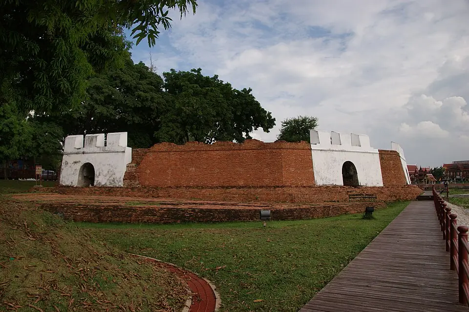
Phet Fortress stands at the south-east corner of the city island, where the Pa Sak River meets the Chao Phraya River. It commanded the southern approach to the city by water, and is one of the two forts of Ayutthaya that can still be seen. In the war of the second fall, the bank opposite the fort, at Khlong Suan Phlu, was the site of the camp of the Chinese volunteers who came out to help in the fighting, until the Burmese broke them early in 1767.
This place through the periods
A large fort commanding the river mouth that was the southern approach to the city. Chinese junks and the ships of foreigners coming to trade had to pass in front of it. The customs-post quarter here was busy with trade in the years when the young Sin was growing up.
This fort commanded the river on the south side during the Burmese siege. On the opposite bank, at Khlong Suan Phlu, about 2,000 Chinese volunteers set up camp in the abandoned Dutch trading post. In February 1767 the Burmese stretched an iron chain across the river, trapped the fleet of Chinese junks and broke it.
The Burmese did not enter the city by this fort but broke through the wall at Hua Ro, in the north-east. When the city fell, the fort was abandoned.
After the fall, most of the city's walls and forts were taken down and their bricks used to build Bangkok in the reign of King Rama I. Only part of Phet Fortress was left.
What remains is a stretch of fort wall by the river in a public park. It is one of only two surviving forts of Ayutthaya. From here you can look across the river to Wat Phanan Choeng.
The water gate of the capital
Ayutthaya was a port city. Chinese junks and the ships of foreign merchants sailed up the Chao Phraya River and reached the city on its south side. Phet Fortress commanded the point where the two rivers meet. The quarter around the fort had a customs post collecting duty on boats, and on the opposite bank were the communities of the Chinese, the Dutch and the Japanese.
King Taksin's father was a Teochew Chinese who came to work as a tax collector in Ayutthaya, so a riverside trading quarter like this was a world his family knew well.
The Chinese volunteers at Khlong Suan Phlu
In December 1766 the court called on the Chinese and the Portuguese to help defend the city. About 2,000 Chinese under Luang Aphai Phiphat set up camp in the abandoned Dutch trading post at Khlong Suan Phlu, opposite Phet Fortress. In February 1767 the Burmese stretched an iron chain across the river, shutting in the fleet of Chinese junks, and then broke it. The Chinese camp held out for about a month before it fell in mid-March.
Although this fight was lost, the Chinese were an important source of strength for King Taksin later on: the Chinese soldiers who broke out through the siege with him, and the Chinese merchants who helped with supplies and trade in the Thonburi years.
Phet Fortress today
The Burmese did not enter the city by Phet Fortress but broke through the wall at Hua Ro. After the fall the city wall was taken down and its bricks used to build Bangkok, so only part of Phet Fortress was left. Today it is a riverside public park. In the evening the light is lovely and it is cooler than in the middle of the day. Standing on the line of the wall you can look across the river to Wat Phanan Choeng and to the line of Khlong Suan Phlu, where the Chinese volunteers' camp once stood.
Phet Fortress on the evening trip
This site's evening trip in Ayutthaya stops at Phet Fortress after Wat Phanan Choeng. Here you see the Pa Sak River flowing into the Chao Phraya in front of the city island. The view explains well why the flood season used to be Ayutthaya's natural rampart, and why the Burmese not withdrawing in the flood season of 1766 changed the outcome of the war.
The fort is an open space and easy to walk around, but there is little shade. On U Thong Road near the fort there are several riverside restaurants, and the roti sai mai shops in front of Phra Nakhon Si Ayutthaya Hospital are not far away.
Phet Fortress is a brick fort whose outline can be seen more clearly than those of the other forts around the city island, so it is a good place to picture the line of the city wall in the years when King Taksin was in royal service.
Visiting information
- Do not climb on the ancient walls, especially on the river side
- In the evening the light is lovely and it is cooler than in the middle of the day
- Cross to Wat Phanan Choeng on the opposite bank by car or by boat.
Frequently asked questions
Where is Phet Fortress?
At the south-east corner of Ayutthaya's city island, where the Pa Sak River meets the Chao Phraya River.
How many of Ayutthaya's forts are left?
Two can still be seen clearly: Phet Fortress and Pom Pratu Khao Pluek.
Last updated 13 November 2026